Comeragh Galtee Phone Map
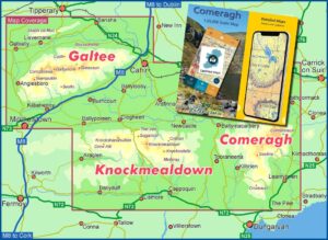
The digital version of the Comeragh Galtee map is now available for the EastWest Maps app running on Android and iOS devices. The EastWest Maps app with test map of…

EastWest Mapping Blog
The digital version of the Comeragh Galtee map is now available for the EastWest Maps app running on Android and iOS devices. The EastWest Maps app with test map of…
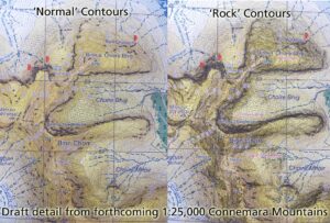
I've been making fairly steady progress on a new 1:25,000 scale map Connemara Mountains. Was planned to go to print by around month end but some fieldwork required and there…
If you use Facebook and would like a couple of news items a week relating to our mapping work - observations on placenames and all that sort of thing, then…
There are currently three distinct parking symbols on our maps, though they vary by edition. Please refer to your map. 1) Public car park, standard purple square with white letter…
An interesting snippet from the Liam Price Notebooks taken at Wicklow District Court on October 2nd 1935: "I got the true form of Glendasan. Christopher Lawler, carpenter, said in Wicklow…
Like many hundreds of other people around Ireland and abroad, I was saddened earlier this week to hear of the passing of Joss Lynam (1924-2011). I knew Joss first through…
Prince William's Seat and Knocknagun. These are the OS names for two popular hills between Glencullen & Glencree and people often enquire as to the identity of Prince William. It…
Where is Kanturk and Brown Mountain? I've always thought that Kanturk was the area of low hillocks and crags, opposit Cloghoge and overlooking the Inchavore but I've discovered recently that this…
From Clive: I went up and found God's Well using your new info.... It's a spring, with exceptionally clear water. May or may not have had stonework around it, its…
This is a name I've come across up near Scarr & the Bracket Rocks - I thought it was the Lough Spit Stone on account of view of Lough Dan…