Where is Kanturk and Brown Mountain? I've always thought that Kanturk was the area of low hillocks and crags, opposit Cloghoge and overlooking the Inchavore but I've discovered recently that this is incorrect. One possible meaning of Kanturk is Ceann Torc or the 'head of the wild boar' and the bumpy nature of the ground perhaps lent itself to that, adding credence. This is one area that has been puzzling me for a while so I've spent a bit of time investigating the matter.
First let's look at the historical record: The 19th century OS six inch maps do not have any mountain names here, just the main townland names – Carrigeenduff, Carrigeenshinnagh and Drummin. The 20th century OS one inch Wicklow District carries the name Scarr for the highest point – 2105 ft. Maps that predate the OS have some townland names but again no apparent mountain names. Again the names Carrigeenduff and Carignashanough (Carrigeenshinnagh) are prominent. In modern local use, these tend to be contracted to 'Duff and 'Shinnagh i.e. that's the Shinnagh Lane etc.
Liam Price in his enquiries (1920-50's) has varying accounts. First it is apparent that Price recognises the name Scarr as the highest point and this must have been the understanding in his time. He does get a couple of accounts from local people that indicate than Kanturk, Kanturch or Canturc is the southern ridge of Scarr towards Killalane, overlooking Drummin or even a name for Scarr as a whole – 'Some calls it Scarr but the right name is Kanturch'. He also gets an account that looking from Glenmacanass waterfall, that Kanturk joins onto Barton's Hill (Scarr) in 'Shinnagh – this would be the northern side of Scarr. Incidentally, Price also speculates that Knockree is a possible old name for Scarr as it's a name recorded in Drummin in the 17th century.
J.B.Malone in Walking in Wicklow (1964), a source of information for many walkers, seems to indicate Kanturk Mountain as the area where the current OS sheet 56 has it named along with Brown Mountain. I was involved in a map of the area for Tiglin in the 1980's and published the name Kanturk Mountain there – I always knew it as that, I think from JB's writings.
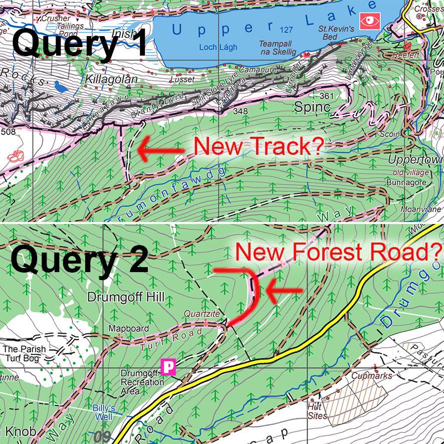
I made some enquiries last year (2010) from local people and seemingly got several different answers as to where Kanturk and Brown Mountain are. I published what seemed to make sense at the time on our Wicklow Mountains West map but had some doubts. I decided to make further enquiries for our forthcoming Wicklow East sheet to see if we could achieve some consensus. I enquired again from six local people who have lived on, farmed and/or grown up in the immediate area. They are more or less agreed that in their time, the following applies: Scarr is the name of the highest point. Going from the top of Scarr towards Glenmacanass waterfall, you drop down and then come to a small rise – this is Kanturk or Kanturch etc. From there, you drop down to a flattish area where there is a stone pillar (standing stone), this is the Lock Spit Stone (note that spelling on map below is wrong, the term is lock-spit, an old word connected with digging/ boundaries etc) – it's on the townland boundary and near the junction of three townlands – the Lock Spit is described as a boundary. From this stone, you rise up to the area of bumpy hills with small crags – these and this hill area is known as the Bracket Rocks (note, not Kanturk). The Lodge is the steep NW slope of same down towards the Inchavore River. Brown Mountain seems better known to those on the east side of the mountain – Míchael Gaffney & Tom Kinlan both of whom live directly below have it as part of the Carrigeenshinnagh ridge or spur. There are a couple of prominent little hillocks on the Shinnagh spur and Brown Mountain is this area – it is clearly seen from the valley of the Duff Brook, where the access route starts. Finally The Crap is the name of the end of the eastern spur running from the Bracket Rocks, where Harvey have their Brown Mountain – Crap or Crop seems to come from Cnap – a hillock or lump. Having said all that, I'm under the impression that the name Kanturch still carries more weight in local use than Scarr and that it may originally have been applied to the hill as a whole.

CG Thompson listed a name Cloghoge Bracket Rocks with no location; when Price enquired after them, he was told they were on the S side of Cloghoge overlooking Inchavore. It's quite possible that the Bracket Rocks and the Cloghoge Bracket Rocks are the same place, though the prefix Cloghoge would place it more firmly on Knocknacloghoge as Cloghoge was and is the local name for that. The Bracket Rocks we are talking about above definitely lie in Duff. It's also equally possible that the term Bracket Rocks refers to the slabby nature of the outcrops and could be applied on both sides of the Inchavore valley. The little rocky outcrops around the top of Cloghoge are quite similar in nature to those on the southern side of Inchavore. What 'Bracket' means, I'm not clear – it looks like an English name but perhaps it's connected to the Irish Breac – meaning speckled or dappled?
In summary, it seems that the name Kanturk for the area of low hillocks and small crags has been picked up incorrectly – this is the Bracket Rocks. This misunderstanding possibly stemmed from JB Malone, was perpetuated on the Tiglin Glenmacnass map and repeated on OS Sheet 56 and our recent Wicklow West map.