Sugarloaf Way Update
Sugarloaf Way Update Map update for our Wicklow East 1:25,000 print map. The Wicklow Way is a popular signposted walking trail and there have been moves afoot for many years…
Continue Reading
Sugarloaf Way Update

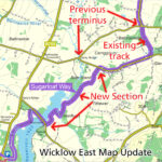
Sugarloaf Way Update Map update for our Wicklow East 1:25,000 print map. The Wicklow Way is a popular signposted walking trail and there have been moves afoot for many years…

Search The Blog Over the past several years we have been posting information at least weekly to our Facebook & Instagram pages. On matters concerning mapping news, map updates but…
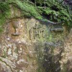
Mass rock in Glencree This large two metre high granite rock with religious carvings lies on the west bank of the Askabawn Stream that runs into the Glencree River. It…
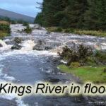
Kings River, West Wicklow The Kings River is a major tributary of the Liffey. It rises up near Wicklow Gap and flows down a broad valley terminating nowadays into Poulaphuca…
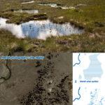
Pool & Hummock Terrain - a cartographic challenge I'm currently preparing a map of the Nephin Beg area in Co.Mayo - this will incorporate both the Wild Nephin project and…
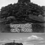
Percy's or Pierce's Table I have written on another post about the mountain Lugnaquilla when viewed from a distance. Here is a photo of the summit cairn, topped by a…
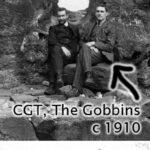
Charles Thompson (CGT) - science teacher, mountaineer and collector of place names A good number of placenames in Wicklow have been added to our maps in the past year. Some…
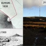
Kippure - The Pole Kippure is a townland and also the name given to the highest mountain in Co.Dublin at 757 metres in altitude. Straddling the Dublin/Wicklow border, it is…