Percy’s or Pierce’s Table
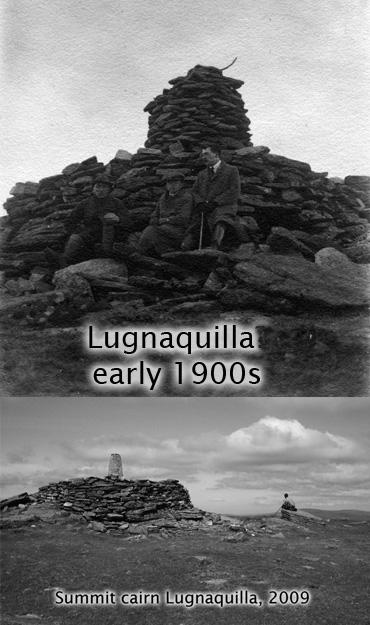
I have written on another post about the mountain Lugnaquilla when viewed from a distance. Here is a photo of the summit cairn, topped by a concrete survey pillar constructed for the re triangulation of Ireland in the 1950s. Also a photo from the Charles Thompson collection taken about 100 years ago, which although unlabeled, is very likely of the same cairn and which shows the original survey pillar.
Now ‘Percy’s Table’ is a name recorded on most OS maps. Some writers clearly think the table refers to the flat plateau of the summit area, however all indications are that Percy’s Table is a more specific site. Liam Price says it is an outcrop of rock, named for an early 18th century landowner called Percy. The OS name book apparently records that it is/was a rock on which a Colonel Percy used to dine with his shooting party about the year 1700. Price may have derived his info from the OSNB and whilst it’s quite possibly the origin, it does seem an improbable place in which to dine in any comfort!
We do have an alternative version by the Rev George Wright (1794-1877) who researched and wrote the popular ‘A Guide to the County of Wicklow’, published 1822 and reprinted several times. He visited Wiseman’s Inn (now Glenmalure Lodge) in 1822 and accompanied a local guide to the summit. The written account is entirely plausible and matches the ground well, so there is no reason to doubt it’s veracity. After describing the smooth green sod of the summit area, he continues as follows ‘the highest point is marked by a large stone, resting upon small and low supporters, not unlike a druidical cromlech, called Pierce’s Table.’
This raises several questions – was Pierce’s Table some sort of portal or wedge tomb? There are several surviving Neolithic tombs on hilltops in Wicklow and elsewhere in Ireland but they usually take the form of a burial chamber covered with a large cairn of stones. It’s possible this was a similar feature but was once covered in earth and sod due to lack of nearby rock & stone, which earth and sod eroded to leave the chamber exposed? However local rock is found on the nearby western slopes towards Camara, unless this was covered in this period?
Does the slab still survive in a collapsed state? Is it the large slab on which the chap sits in the main photo or is this part of the bedrock? Or some other nearby slab? Did the Ordnance Survey break it up in the 1820s/30s when they presumably built the large cairn for their survey pillar? I haven’t been up there recently, so if any reader is climbing ‘Lug’ in next while, please have a look around and report back!
As to Percy or Pierce, it’s hard to know – the latter has a ring of truth maybe. However there is evidence of Percys living at Stratford on Slaney in Griffiths Valuation of the 1850s, which wouldn’t be too distant. Whereas Pierce seems to be more of an east Wicklow or Wexford name.