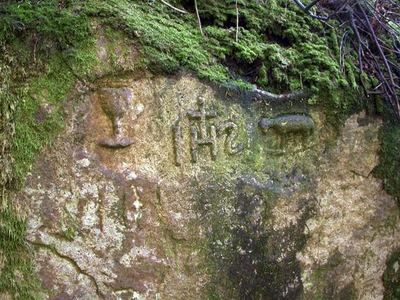
Mass rock in Glencree
This large two metre high granite rock with religious carvings lies on the west bank of the Askabawn Stream that runs into the Glencree River. It can be found about 80 metres from the roadside carpark at the German War Cemetery. Go in through the graveyard and climb up the right bank steeply, cross a broken down fence and after a few metres, descend rough ground to gain the bank of the stream, where you may find it. There are three carved symbols – a chalice, the initials IHS and a lamb. Perhaps the combination and use of these symbols can be used to date the carving? IHS as a religious motif has been in use since the seventh century.
I came across it when enquiring after placenames etc in Glencree and my informant advises me that he learnt of it from a local lady (now deceased) who used to periodically clean it off. Both she and her husband were aware of it and called it a mass rock but it otherwise seems unknown to other local residents. I surmise therefore that knowledge of it dates back to at least the 1950s.
Mass rocks & sites are rather nebulous features in the Irish countryside, they rarely carry carvings and the knowledge of them is kept alive mainly by local tradition. They are primarily associated with the period of the Penal Laws in the eighteenth century, when the saying of the mass was suppressed and people gathered in out of the way spots to celebrate same. However it also thought that the celebration of outdoor mass was common enough prior to this period and that the tradition was merely strengthened and/or revived in Penal times.
A question arises though as to whether this is a genuine mass rock or were the carvings made by a member of the Oblates of Mary Immaculate, an order who ran the adjacent St.Kevin’s Reformatory from the 1850s to 1940. One would consider that if there was a genuine tradition here that greater local knowledge would exist. On the other hand, such features are often forgotten about as older generations die out. It lies in a fairly secluded spot although it would plainly have been awkward for a large crowd to have gathered here. There is another known mass rock called Castle Toole about two kms east of this location, high on Cloghnagun mountain. By way of contrast Castle Toole is on the open hillside and any crowd would have been visible.
What we can be reasonably certain of is that if this was a mass rock, it predates 1800 as we find the Military Road and Glencree Barracks constructed in the first decade of the nineteenth century. Prior to this, there is evidence to suggest that a rough road/ track ran up from Enniskerry towards this site where it probably terminated or continued roughly onwards to connect to Glenasmole. Either way, this was a remote corner of the hills and the government of the day moved to build a chain of barracks to bring rebel Wicklow under control following the 1798 rebellion. The proximity of the rock to the new barracks, later reformatory and now the Glencree Centre for Peace and Reconciliation would have rendered it useless after about 1802.