Pool & Hummock Terrain – a cartographic challenge
I’m currently preparing a map of the Nephin Beg area in Co.Mayo – this will incorporate both the Wild Nephin project and the Ballycroy National Park and will hopefully be published at a print scale of 1:25,000 in 2015.
It’s very different terrain to Wicklow and the south east, a mixture of steep mountains and flat blanket bog. One of the cartographic challenges is how to represent the pool & hummock complexes that characterise many parts of the blanket bog. There isn’t space here to elaborate on how this terrain forms – use Google! The end result however is sometimes called a ‘quaking bog’ which gives a good idea of the nature of the ground. An area can contain dozens to hundreds of small pools separated from each other by drier hummocks, both of which support different vegetation. Many of the pools have an elongated shape with the long axis developing along the slope and often the pools coalesce into larger ponds and small lakes.
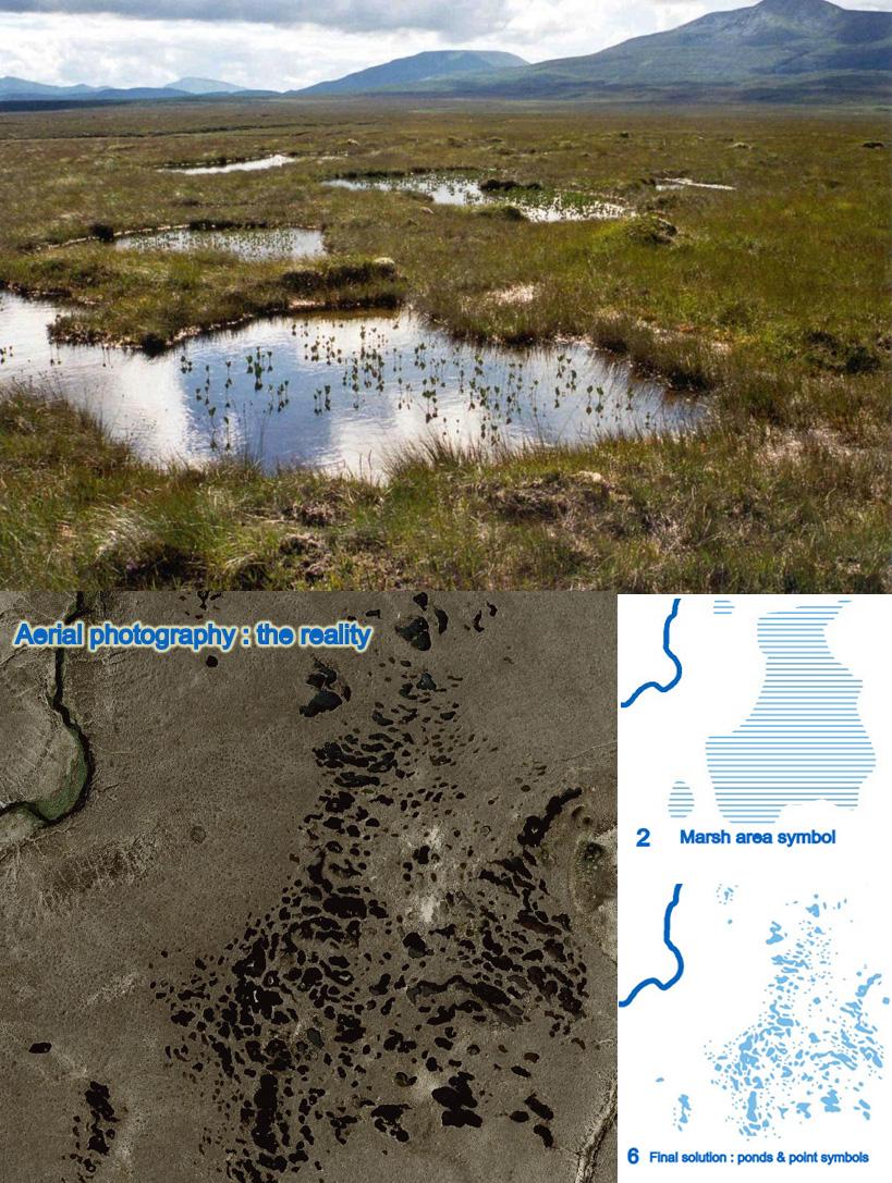
The aerial photo here is of part of the Nephin range and gives a good idea – it covers about a quarter of a square kilometre but contains 350+ pools. The second photo is from Ballycroy National Park and shows what this terrain looks like on the ground – you’d want to be careful venturing too far into such ground, particularly if unaccompanied!
My problem though is how to efficiently represent this on a map, so that it both conveys the nature of the ground but is also reasonably accurate. Where I’ve encountered this terrain before on say the Liffey Head bog, I’ve just drawn each pool by shape, tedious but manageable for small areas. Clearly the Nephin area needed some rethinking and the following set of graphics show various solutions I considered:
1 The bare bones – nothing
2 Marsh area symbol – conveys the idea without any idea of pools or lakes, quick and easy to apply.
3 Blob area symbol – variation on above but perhaps too regular and not suited to small areas
4 Large ponds only – contains 40 of the larger pools and ponds (greater than 25 metres) drawn to scale, getting there but compare it to the original aerial view – 300+ pools missing. Also compare the Ordnance Survey Ireland solution at the end – they use this style but show just 10 of the ponds.
5 Large ponds and marsh symbol – gives a better idea but not entirely satisfactory.
6 Ponds and point symbols – my final solution. This combines the 40 larger pools above with a series of point symbols for the smaller pools. I noticed that many of the small pools have fairly generic elongated and round shapes and created a series of point symbols for pools sized 5 metres, 10 metres, 15 metres and 20 metres. It’s then relatively simple to select, say a 10 metre pool symbol and apply this to all pools of this approx size in a given area, rotating to suit the direction. Ditto for other sizes and shapes.
I think you’ll agree that it works fairly well – compare it to the aerial photo. It gives a good idea of what to expect in this area and also shows the shape and layout of the pools well. It’s not perfect as the generic pool shapes don’t always match reality exactly but is a good compromise.