Thoughts on Navigation ~ Map and their Makers
Some maps are better suited to your purpose than others but any map is better than none at all! You’re bound to come across maps from a wide variety of sources. When you use them, you should ask a few basic questions:
– who made the map?
– why did they make the map?
– what techniques were likely employed in the map compilation?
– when was the map made?
Who made the map? Was it a government agency, a local tourism group or an individual etc? Government agencies such as national survey organisations are often obliged to generate a set of maps at a specific scale across a region and they must choose a method and set of standards that can be applied across the entire area. A local tourism group may publish a map made but have it slanted to suit the needs of local businesses. Individuals or small cartographic companies are less constrained than government agencies and can compile a map to suit a specific area.
Why did they make the map? Agencies and people make maps for all manner of different reasons and these reasons will affect the type of content shown. Compare an orienteering map surveyed and drawn for this navigation sport to a map constructed for military or taxation purposes. A company supplying navigation maps for car sat navigation systems, clearly makes maps of the road network and associated services. They are rarely interested in what lies between the motorable roads, except perhaps in city areas. Consider the difference say between an Ordnance Survey Ireland map and that produced by smaller specialist companies such as EastWest Mapping, Folding Landscapes or Harveys – the former as part of a formal scheme, the latter from people with a greater interest in promoting the specific areas.
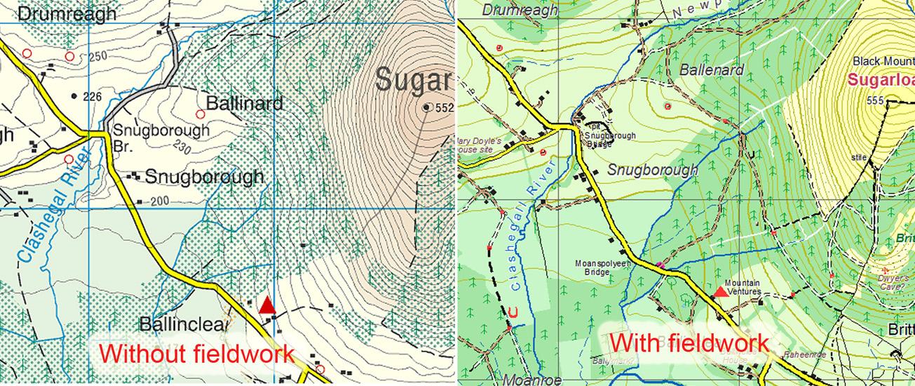
What techniques were likely employed in the map compilation? Modern small scale mapmaking is increasingly dependent on aerial imagery, whether flown by plane or satellite. In Ireland, the OSI Discovery map detail is largely based on aerial photography, flown at ca 3,000+ metres in altitude. The resulting map detail is dependent on the photo interpretation skills of the operator and tree cover. Where forest is mature and particularly if it’s broad leaved, much ground detail is hidden. Quoting from Richard Kirwan who oversaw the Discovery map project, ‘a completely new map of the country had been produced using aerial photography, computers and a small amount of fieldwork’. This is very obvious in forested areas with considerable inconsistency in the recording of Discovery map detail due to lack of fieldwork. By contrast, a cartographer like Tim Robinson saw it as his business to look at every piece of the countryside that he mapped in Connemara. Since the end user actually views the map from ground level, clearly the latter approach will yield a more useful result. Other government agencies use varying amounts of fieldwork combined with remote data capture. The only practical way to judge the quantity of fieldwork is to use the map on the ground when it will become apparent. When you use a map from the Discovery Series, you should keep this aerial view in mind when trying to understand what features are mapped.
When was the map made? Depending on the amount of human intervention and development, maps go out of date in varying periods of time. Maps constructed prior to the Celtic Tiger building boom in Ireland are quite likely to be seriously dated in places as regards roads, one off houses and bigger developments. In more rural areas, forestry grants have had a significant impact on the countryside and with a new scheme in progress, this change will likely continue. Agencies such as OSI, depend to some extent on other bodies supplying them with info, so you’ll often find Coillte plantations mapped but adjacent private planting has slipped by without notice. The discerning user can still make good use of such a map though, once they take into account the date of publication and see through the missing detail.
All maps are not equal, some are better suited to your purpose that others but any map is better than none at all!