Thoughts on Navigation ~ Map Reading
Apart from route finding, map reading is the key skill underlying all navigation on terra firma. Relative novices learning navigation skills will often concentrate on techniques such as distance measurement, compass work, using GPS and understanding grids etc. There’s no harm in this but it’s essential to grasp that the successful application of these and other land navigation techniques all rely for their success on the bedrock of map reading skills. You should think in terms of two facets when it comes to map reading, one is the mirror image in a way of the other, though they both require separate practice.
The first skill is looking at a map, understanding the information and then forming a mental picture of the terrain. You should be able to visualise the terrain – see example attached of Blackstairs. Not only is this skill useful when planning a walking route, it is essential when you are navigating in conditions of poor visibility. You shouldn’t just blindly follow a compass bearing in mist, expecting to arrive miraculously at the required destination. You need to look at the map and after measuring your bearing, visualise the terrain that lies along the direction of travel that you’ve just measured. As you follow your bearing in the mist, you cross check this mental picture against what you see around you. If it matches up, well & good. If it doesn’t, something is awry – either you’ve wandered off or you weren’t where you thought you were when you started (or the map is wrong/ out of date).
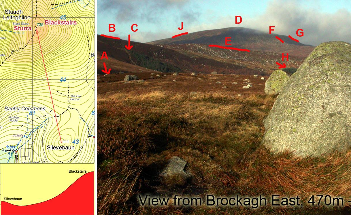
The second skill is the obverse, looking at the terrain round about you and understanding where the landscape features that you can see, are marked (or are missing) on the map. This is the basis of self location when you are navigating. If the weather is clear and the route straightforward, then in practice you only need to know roughly where you. If the weather is mixed, the route is complicated and/or visibility is closing in, you need to know exactly where you are on the map. See example attached based on a view from Brockagh East, 470m near Laragh in Wicklow. The corresponding map is either of our Wicklow West or Lugnaquilla & Glendalough sheets.
The best way to learn and hone these skills is to be constantly curious, even when you don’t need to be! If you go out on a walk or whatever in good clear weather, keep the map handy and examine it as you go along. Look at the map detail, visualise the features and check that mental image against reality. Spot features around about, both near and further away and look to identify them on the map. Be able in the moment to point to the best estimate of your position. As you progress, keep updating that position. If you practice these map reading skills, even when you don’t need to, then they will stand you in great stead when the cloud and rain rolls in and you need to understand where you are and where you’re going!
In my book, you can never be too good a map reader – there’s always room for little surprises and misjudgements. Of course maps differ in how they are compiled and how features are represented, coming up next 🙂