Sally Gap
Mountain passes in uplands have always been important as the easiest means of crossing difficult high ground. In Wicklow, the three main passes are Sally Gap, Wicklow Gap and the…
Continue Reading
Sally Gap

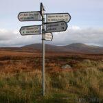
Mountain passes in uplands have always been important as the easiest means of crossing difficult high ground. In Wicklow, the three main passes are Sally Gap, Wicklow Gap and the…
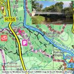
Samuel Hayes Bridge Update Thanks to map user Isobel O’Duffy for supplying details of the newish Samuel Hayes footbridge across the Avonmore in Co.Wicklow. This update applies to our Wicklow…
If you ran the IMRA (Irish Mountain Running Association) Wicklow Way Half Marathon last Sunday, you should have received one of these unique buffs/ snoods as a reward for your…
In recent years Ireland has experienced a steady increase in the number of people seeking out the benefits of outdoor exercise. Good for both mind and body. Associated with this…

The last hillwalking photo from Charles Thompson is a panorama taken from Stony Top or Cleevaun East looking east towards Lough Dan & Cloghoge Mountain. Note the almost complete absence…
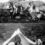
Today’s Charles Thompson image is from Djouce, a very popular and much photographed hill in east Wicklow. The chaps are having a wee dram at the summit tor. Note the…
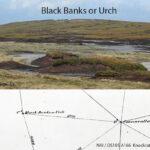
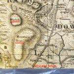
I’ve written previously about the name ‘Table Mountain’ in the Wicklow hills and reported that locally this area is still known as the Black Banks. That the name Table Mountain…
War Hill is a round boggy summit adjacent to Djouce (usually spelt Douce on older maps). War Hill is an odd but old name, found on the earliest detailed map…