Mer de Glace & global warming
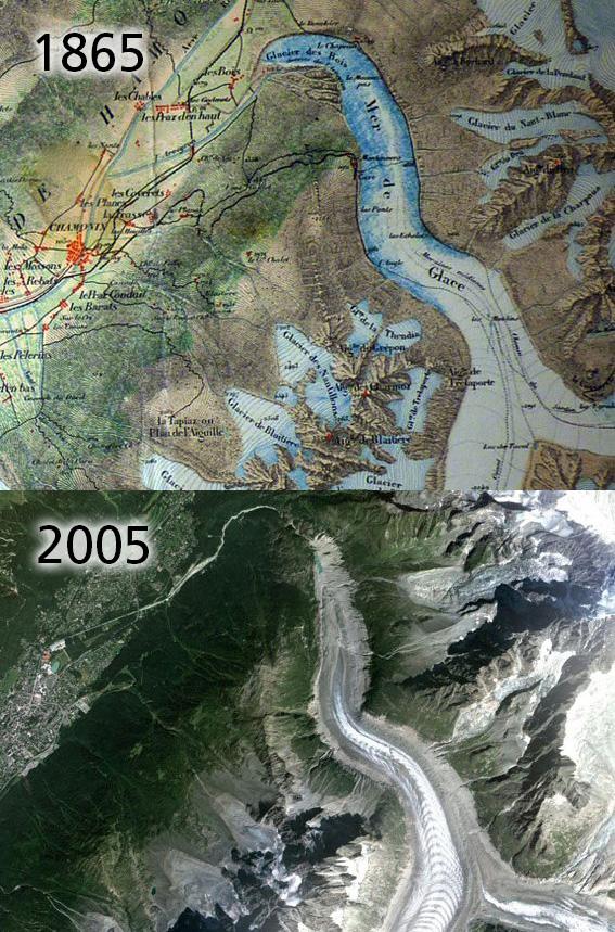
Global warming is in the news a lot these days and one of the oft quoted pieces of ‘evidence’ is the retreat of the glaciers in the European Alps. I’m sure there are photos taken in the latter 1800s but here is some interesting map evidence. This is an extract from a map entitled ‘Massif Du Mont Blanc’, published in 1865 and a very fine example of early French cartography.
The famous glacier called the Mer de Glace or ‘sea of ice’ is shown flowing down to terminate at a height of about 1125 metres above sea level and only about 100 metres in height above the valley floor where Chamonix lies. The lower part of the glacier is called the Glacier des Bois or the ‘glacier of the woods’ as it penetrates down the wooded sides of the valley.
By contrast, here also is a modern Google image, showing the Mer de Glace and area as of this decade. The glacier now terminates at about 1500 metres above sea level and some 3 to 4 kilometres further back up the mountain. The Glacier des Bois section has disappeared completely. When viewing the satellite image, note that the actual ice is bordered by stone moraines. These are a mixture of ice and rock near the centre and just stone & rock at the sides and below the permanent ice.