Where are the Monavullagh Mountains?
The name Monavullagh Mountains has been applied by the Ordnance Survey to the southern end of the Comeragh Mountains since the 19th century. On OS publications it seems to broadly cover the area from Milk Hill to Crohaun and is known to map users and walkers etc.
However it is apparent from talking to local residents in the area that they are not aware of any upland range called the Monavullagh Mountains and are at pains to point this out. They either refer to individual hills or use the name Comeragh Mountains for the whole.
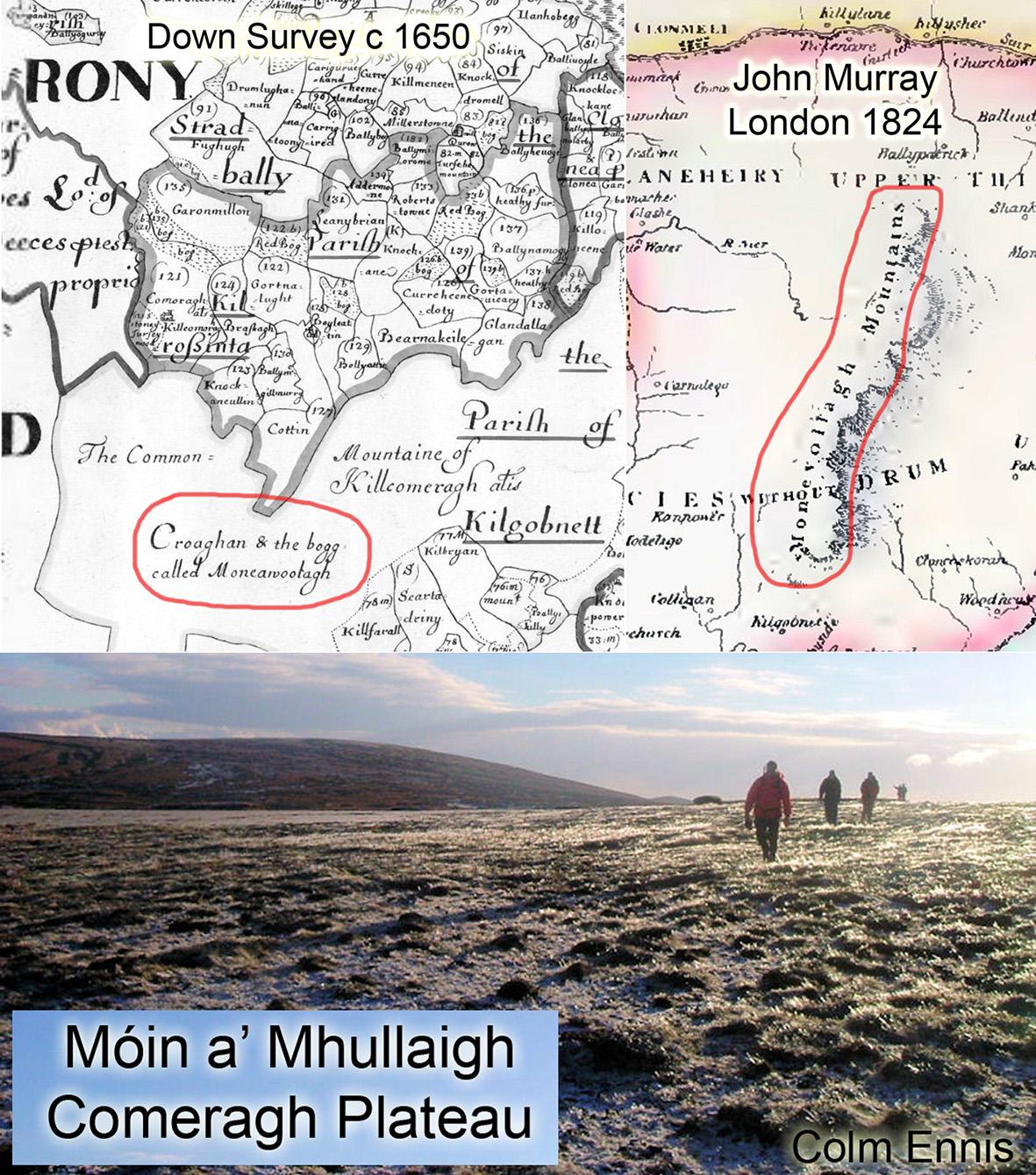
The name Monavullagh is certainly known locally. It’s from the Irish Móin a’ Mhullaigh said like Moan-a-wulla or Moan-e-vulla and meaning the bogland or turf bog of the summit. From my enquiries, Móin a’ Mhullaigh is known as a name for two distinctive areas. The first is the high summit plateau of the Comeraghs between Comshinaun (Coumshingaun) and the Scilloges. A high wet land with several places you can easily sink up to your knees. Canon Power in 1907 records Móin a’ Mhullaigh in this townland of Kilclooney and it is pointed out still as a name for that plateau. Likewise the Schools Collection of c1938 for Glenanore describes a flat tract of réidh called Móin an Mhullaigh in this area. Secondly the name Móin a’ Mhullaigh is still known for specific areas of turf bog in the Farbreaga area above the Mauma Gap. However in both instances, these are specific places rather than an overall name.
There are several historical records of the name and clearly it has been in use for at least 350 years. The Down Survey of c1650 depicts an area ‘Croaghan and the bogg called Moneawullagh’ in the Mauma area. The ‘Ancient & Present State of Waterford’ etc., by Charles Smith, published 1774 describes ‘a high table land called Monevullagh, about 500 yards above the sea’. Likewise the Rev Ryland in 1874, includes a map in his book ‘History, topography and antiquities of Waterford’, showing the name Monevollagh Mountains write across the full range from Crohaun to Knockanaffrin. However the text of both books and others of this period also refer to the Mountains of Cummeragh or the Cummeraghs.
I can only speculate at this distance but I think the situation was likely broadly similar in Charles Smith’s time. That is, the local people pointed out various places called Móin a’ Mhullaigh whilst speaking of the Mountains of Cummeragh or the Comeraghs. And that these were conflated by various authors/ cartographers into a collective term, the Monavullagh Mountains which doesn’t exist in local understanding per se. And which name, was applied in turn to Ordnance Survey publications.