What gives us our weather are air masses of different natures: warmer, cooler, wetter, dryer, unstable, stable etc and then how these air masses mix together and influence each other. These differing air masses move across our island, sometimes quickly and other times slowly. Weather forecasters pay great attention to these details so as to judge how they will affect us day to day.
As air passes over the earths surface, it tends to pick up the characteristics of the surface. So air moving from the west towards Ireland picks up moisture from the ocean, whereas air coming in from the east and continental Europe tends to be drier. Ireland being where we are on the west edge of Europe is what gives variability to our climate. The Atlantic is the biggest influence and moderates our weather, smoothing out highs and lows of temperature and rainfall.
In the last post, we looked at weather charts and how to judge the wind direction from the isobars. If we follow that air backwards to it’s source and particularly over a day or two, we can judge where the air has originated from, it’s likely nature and therefore effect on us.
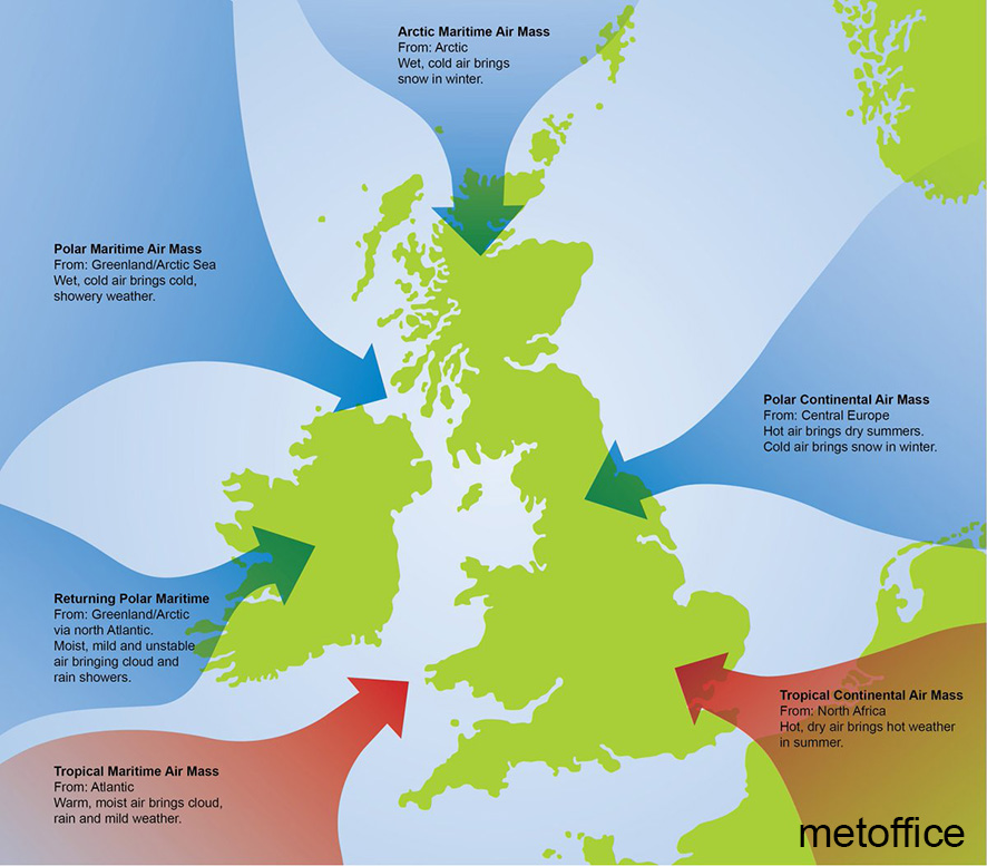
The chart pictured here gives detail but we can generalise as:
– Any air mass moving in from the west and south west (our prevailing weather) tends to give milder temperatures and periods of rain. There’s not a big difference winter & summer as the Atlantic whilst wet, never gets very hot or cold. We get ‘wet & cool’ days on the hills in winter and ‘wet & warmer’ days in summer.
– An air flow from the north west is also common. It’s usually wet and less stable, brings bright cool weather with heavy showers: rain in summer, sleet/ snow in winter.
– An air flow from the north is always cooler: chilly in summer and with snow showers on hills in winter.
– Any air flow from the east, south east and even south is a bit trickier. The continent is the bigger influence, and this large landmass unlike the ocean tends to cool down in winter and get hot in the summer. So depending on the time of year, weather from this direction can be either bitterly cold/ even snowy or produce heatwaves.
Having a rough idea of how different air masses affect the weather on our hills according to the time of year is very useful. So look at the charts and listen to/ read the forecasts to establish this.
To be continued. #eastwestmapping