Thoughts on Navigation ~ Measuring & Estimating Distance
The ability to measure distance from a map and then estimate this distance as you walk is a useful skill. You should always make a rough calculation before you head out on a route that you have not walked before, just to get a handle on how long it should take. In conditions of poor visibility it’s useful to be able to estimate distance between features that you navigate by.
The standard guide for estimating how long a walk will take is provided by ‘Naismith’s Rule’, that is allowing for a walking speed of 5 kilometres per hour plus 1 extra minute per 10 metres of ascent. So a walk of 15 kilometres with 700 metres of ascent might take 4 hours 10 minutes (3 hours for distance + 70 minutes for ascent). You need to add in about an extra hour for stops and breaks for this sort of route – so the route might take a bit over 5 hours. There are many variables, if the ground is pretty rough or boggy/ wet underfoot or a person in your group is slow, you’d want to use 4 kilometres per hour or less. Always keep an eye on when you expect it to get dark or timetables and start with sufficient spare time in hand. There is plenty of detailed information and worked examples to be found online for ‘Naismith’s Rule’ – Google the term for further assistance.
In conditions of poor visibility you will need to navigate from one feature to another e.g. from a hill summit down a spur or ridge to a point when the spur divides and you want to follow a particular branch. In this instance, it’s important to be able to judge when you should be arriving at the point where you must take care to follow the correct line. There are two standard techniques for this: calculating and measuring time as above and/or secondly pacing or counting your steps. The time calculation is made as above, allowing for roughness of terrain. Pacing is based on the idea that most people on even ground walk with a steady stride, typically 120-140 steps for each 100 metres. In practice you count double steps, each time say your right foot hits the ground – so 60-70 double paces for 100 metres. You measure the distance on the ground by counting out blocks of 100 metres, easier said than done as it requires concentration.
The reason that I discuss how you estimate distance walking firstly is that you much appreciate that both techniques are approximate and must be used carefully in conjunction with map reading. It’s generally taken that an error of 10% is normal in estimating distance by timing, some place it nearer to 20%. Pacing is usually stated to be more accurate but this is very dependent on the terrain and can be very difficult to apply on steep or rocky terrain. If in the example above, you needed to stop after 1 km or 1000 metres, you’d aim to walk for 12-15 minutes based on terrain (don’t forget you need some sort of watch to measure this, which not everyone carries now) or you’d count off 10 sets of 100 metres by pacing. You’d be doing pretty well to pull up anywhere between 900 and 1100 metres, just by trying to judge how far you’ve traveled.
It follows from this, that when you are measuring distances on the map, there’s little point in trying to figure it out as exactly as possible, perhaps to the nearest millimetre or 25 metres on a 1:25,000 scale map. Because you can’t rely on measuring that distance accurately on the hillside. In fact, using conventional techniques like above, you’ll be fine to judge the distance to the nearest 100 metres on the map and of course, combine this with map reading. Note that you might be asked to come up with a more exact reading on some sort of mountain navigation course or test but I’m talking practical reality in real conditions.
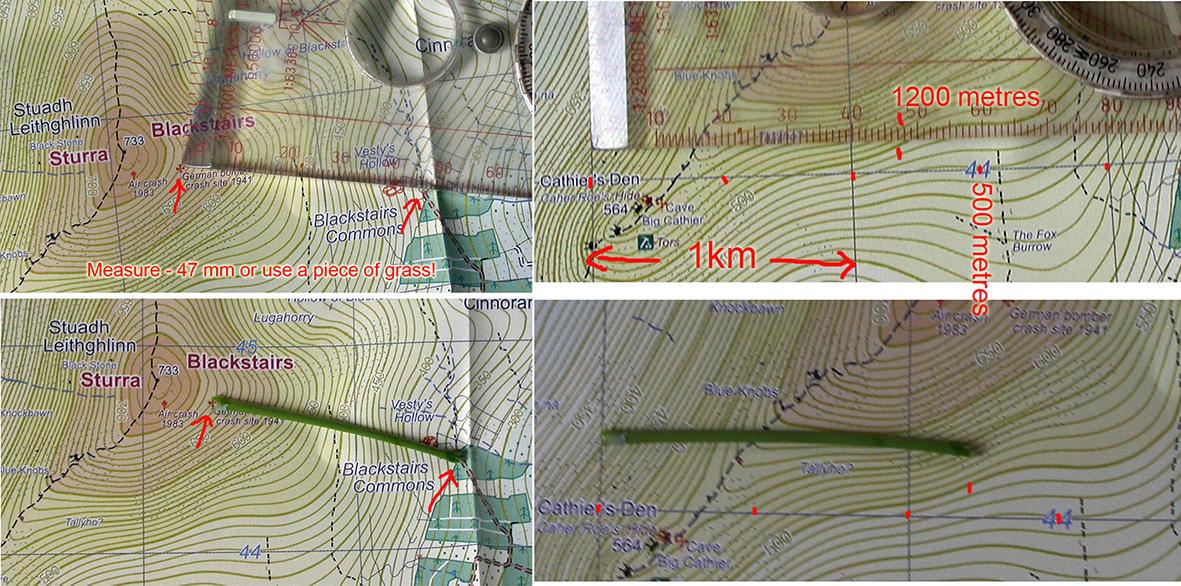
As regards measuring distances on a map, there are various techniques well explained online, measuring centimetres/millimetres on the map and converting to metres & kilometres, using romers and so on. Map scales vary, the most common scales used nowadays for this type of navigation are 1:50,000 and 1:25000 where 1 centimetre on the map represents 500 metres and 250 metres respectively on the ground. Regardless of scale, most such maps have a ready way of estimating or measuring distances, which is the grid of squares on the map face, each being 1 kilometre or 1000 metres in height or width. This gives a handy way to quickly estimate distance by counting squares or part of, without any need for mental arithmetic and you can use the grid to make sufficiently accurate estimates to the nearest 100 metres. Simply measure the distance in centimetres or millimetres (or any graduations you wish) using the scale on the side of your compass or even use a stalk of grass. Remove and place this along the grid squares, parallel to the grid lines. Read off the number of whole kilometres and then estimate the remainder. For the portion of a kilometres, most people can judge halves of anything accurately, so split a kilometre square visually into two 500 metre sections and then you should be readily able to estimate the remainder to the nearest 100 metres – see example.
The 1 km grid on the map face is in fact a readymade romer, which with a little practice is quite suited to measuring distances with sufficient accuracy to the nearest 100 metres, regardless of what scale your map is printed or displayed at.