Thoughts on Navigation ~ Compass
A compass is a handy tool in your navigation kit. Any compass is useful but a protractor type as shown in the photos here is normally used for hill navigation. There are plenty of online videos and instructions as to how to measure and follow bearings etc. e.g. see https://www.mountaineering.ie/content/TrainingResources/92
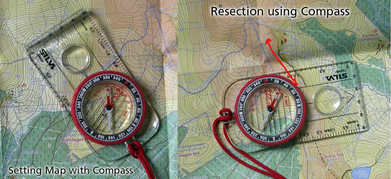
I’d like to touch on the three common applications of the compass as follows:1) the most useful thing you can do with your compass in terms of map reading is to use it to set or orientate your map and/or check that you have it set. If you are map reading as you walk along, normally you will keep the map set by reference to the features about you. However in conditions of low visibility e.g. mist or forest, this is not so easy and is where the compass needle comes to your aid. Simply place the compass flat on the map and rotate the entire map until the red end of the compass needle (Magnetic North) points to North on your map. If you want to be pedantic, you could align a little touch to the West of North but for practical purposes, that’s splitting hairs at present.
2) Following a bearing – what most people associate with compass use. The process is well described in videos etc. above. What you need to bear in mind though is that it is not a ‘magic bullet’ that will bring you exactly to your required destination – the process is best regarded as an aid or extension to map reading and route finding skills. Even careful use of the type of compass shown here will entail some error. In poor conditions, you may easily be a little sloppy measuring the required bearing from the map – cold hands, rain splattered map cover etc. There are various techniques to help follow a compass bearing on the ground but still you may expect to stray a few degrees either side. A good rule of thumb to note is that a lateral error of 10% of the distance may be expected. Example: follow a compass bearing for a kilometre (1000 metres) and you could end up passing 100 metres either side of your intended target. This is where map reading, route finding and distance estimation skills all play a part and need to be used in conjunction with following the compass bearing.
3) Resection – picture this. You’re walking along a well defined ridge, spur or cliff edge in the mist, not quite sure how far you’ve travelled along it. The cloud suddenly parts briefly and you glimpse the valley below, spotting some feature that you can identify on the map. Maybe a corrie lake or forest corner or whatever. You point your compass at the feature and take a bearing as the cloud fills back in. Now subtract the magnetic variation from the reading and plot the bearing on the map as shown in attached photo. You are located somewhere along the compass edge – the intersection of this edge and your well defined ridge, spur or cliff edge etc. is your location.
These are the three most common uses for the magnetic application of the compass in hill navigation. You can of course also use it for measuring distances, magnifying detail, poking people, buttering your sandwiches etc. 🙂