Thoughts on Navigation ~ GPS Units
GPS (Global Positioning System) technology has grown rapidly in recent years. Some people don’t like it all, they go to the hills or sea or wherever to get away from electronic technology. Others embrace it as just another tool, like a compass or a pair of boots. It’s for each person to decide but note that however enthusiastic you might be, you still need to carry a paper map and traditional compass and know how to use them together.
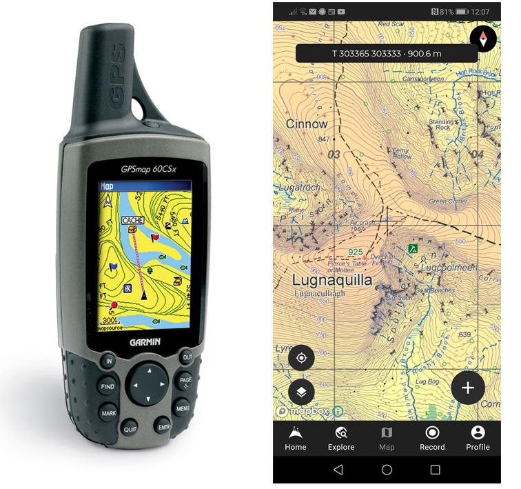
GPS works by receiving signals broadcast from satellites – the devices normally need to be able to receive from four satellites to give you a fix and the more the merrier. Many people are familiar with car sat nav units like Garmin – these are tailored towards road navigation. For hill navigation you currently have two main choices: a dedicated GPS receiver such as a Garmin or Satmap handheld unit or a smartphone equipped with a GPS chip.
The advantages of the dedicated unit such as Satmap or Garmin models is that they are ruggedised and waterproof for normal wind and rain. They normally use standard AA rechargeable batteries and with a little care you can readily change batteries on the hillside. The disadvantage is cost and the fact that each manufacturer has their own proprietary map format, so you must purchase a map format to suit the device.
Smartphones – well many people have them now, whether Android or iPhone and will often carry them with them on the hills. Equipped with a GPS chip and an app such as Hiiker, these phones can emulate the dedicated GPS receiver mentioned above. You’re combining two devices and possibly saving on cost and weight. The disadvantages are firstly that the phone battery can drain down, it’s not normally easy to swap in a fully charged battery and secondly most phones are not ruggedised and waterproof for normal wind and rain! There are strategies to get around this a) purchase a decent waterproof case that allows for touch screen operation b) buy and bring a dedicated battery pack c) switch off all other unnecessary apps d) carry a second basic phone for emergency call use e) use power settings in the app that put the screen ‘to sleep’ after 30 seconds or whatever. It’s quite possible that consumer smart phones that suit ‘outdoor adventure’ applications will appear more commonly in the future, obviating many of the above problems.
Maps for GPS devices: there are two possible formats. The first and least common now (for hill use) is the ‘vector map’ – you’ll be familiar with these from car sat nav units. The data is stored as a series of co-ordinates, so a line like a road is made up of multiple short segments and usually portrayed using a fairly crude symbol. As you zoom in and out, the appearance changes, there is no pixelation or loss of resolution as you zoom in. These maps were and are used on some of the earlier Garmin type handheld GPS receivers. They seem to be able to utilise less power hungry screens and can be used in continuous operation. Finally, as you’ll know from car sat nav, they can be made ‘routable’ – you can enter your start and finish destinations and the unit will choose a route and guide you along it.
The more popular map format now for GPS and smartphone receivers for handheld use is the ‘raster map’. Here the screen map is simply a bit mapped version of the regular print map – the data is stored as a series of dots, like a photograph or scan of the print map. Advantages are that it looks familiar. Disadvantages are that it takes up more storage space and as you zoom in the detail can become pixelated or fuzzy. There’s a trade off between file size and resolution and the vendors use a setting that gives a good enough trade off for most purposes.
All digital EastWest Mapping maps published to date are available for the Hiiker phone app. We don’t have a Garmin solution due to licensing costs for same.