Lugnaquilla & Glendalough Map Update

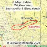
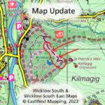
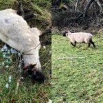
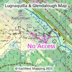
Lugnaquilla & Glendalough Map Update The Zig Zags. Following the recent despicable assault in Glenmalure, Co.Wicklow – please disregard the agreed access route symbol currently marked on our Lugnaquilla &…

Continue Reading Lugnaquilla & Glendalough Map Update

Brockagh Map Update

Brockagh Map Update If you have a copy of our Wicklow West and/or Lugnaquilla & Glendalough map, you might like to note the following map update. Thanks to map user…

Continue Reading Brockagh Map Update

Avoca Map Update

Avoca Map Update If you have a copy of our Wicklow South and/or Wicklow South East map, you might like to note the following map update. It concerns the lovely…

Continue Reading Avoca Map Update

Brown Lines

Brown Lines What are the ‘brown lines’ on maps by EastWest Mapping? We use three line symbols for boundaries/ linear features on our maps ~ in green, black & brown.…

Continue Reading Brown Lines

School & Mass Paths

We are all encouraged to walk & cycle more now as a means of local transport. Cycle lanes and Greenways are built at some cost to encourage sustainable local transport.…

Continue Reading School & Mass Paths

Granite Tors

Granite Tors The Dublin Hills may be modest in height and terrain but they sport a few dramatic outcrops of rock. Granite tors as in the photo here can be…

Continue Reading Granite Tors

Rescuing Sheep

If you wander the hills, farmland or forest at all, you must eventually come across farm animals that are in a spot of bother. You could walk past thinking someone…

Continue Reading Rescuing Sheep

Art O’Neill Challenge 2023

The now annual Art O’Neill Challenge takes place this January 13th. A challenge event journeying overnight from Dublin Castle to Glenmalure and commemorating the escape & flight of Art &…

Continue Reading Art O’Neill Challenge 2023