Comeragh Placenames Part 7
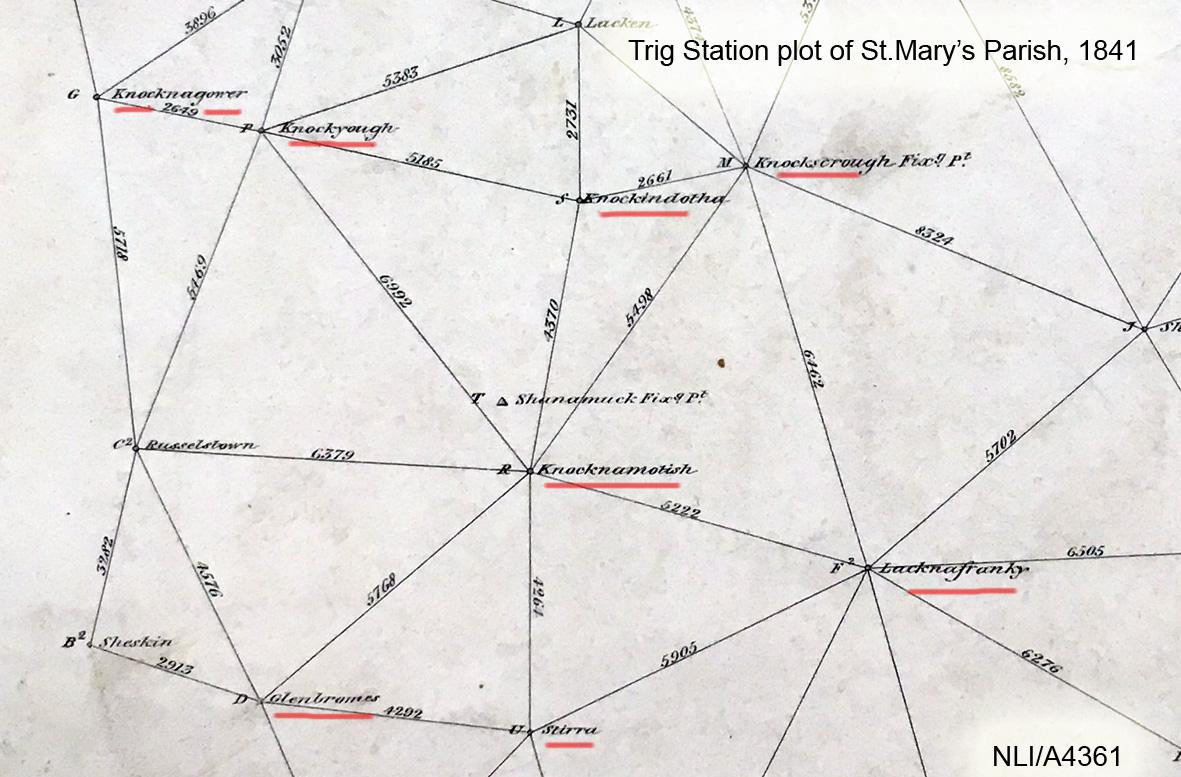
To conclude this series on the Comeragh hill names, we’ll look at the group of hills overlooking Clonmel. The main feature here is the Glenary valley which the hills encircle. The two principle sources for the names used on the Comeragh map in this area are 1) Ben Guiry who often visited and knew the inhabitants of Glenary in his youth and 2) Ordnance Survey field survey records from 1841, there was a ring of minor trig points on the encircling hills and each station had a name.
Ben tells me that Glenary was said like ‘gloun-a-ree’, Gleann a’ Rí by the old people and that it’s nothing to with kings but that here the word rí refers to the arm and in particular a bent arm. And indeed Glenary has a right angle bend or twist in it. The Staighre (steps) path is a well known feature of the area and this runs from Glenary & Clonmel over the hill to Glendalaghin, crossing the Glenary River at Áth a’ Staighre – the Staighre Ford.
The Staighre path left Clonmel and went uphill by Cnoc na nGabhar, where Ben’s great grandfather lived. The same hill had an OS station called Knocknagower, the anglicised version of above and meaning ‘goat hill’.
The Holy Year Cross is oft visited and nowadays would be said to be on Scrouthea Hill. The OS station here was called Knockyough, possibly Cnoc a’ Áth and a reference to the Staighre Ford just below it.
Continuing east from Knockyough, we pass the site of an old British Army rifle range in use between 1880-1920. The next height had a station called Knockindotha (possibly little burnt hill), this leads onto the well known Long Hill or Cnoc Fada. The station name here in 1840 though was Knockskiough, most likely Cnoc Sceach – the ‘hill of the sceachs of bushes’.
We then rise up to the main height of Lacknafrankee, Ben says the ‘slope of the rats’ as in Leac na Francaigh as opposed to Laghtnafrankee – the burial cairn of the Frenchman. And indeed the OS field surveyors concur as they understood it as Lack rather than Laght.
A western spur of Lacknafrankee is Cnoc a’ Chomórtas, Knockamorlish OS station. Ben identifies this hill and says when you walk up the Staighre path it looks to be the same height as hills to south but as you go higher it becomes apparent that it isn’t. So Cnoc a’ Chomórtas means literally ‘hill of comparison’ but perhaps ’emulating hill’ or even ‘false hill’ would be true to the idea.
Continuing west now from Lacknafrankee, we drop down to a pass where the Staighre Path crosses. This area is I believe Mol a’ Staighre mentioned in Crotty’s famous poem, Mullach Staighre – the height of the Staighre Path. Stirra was the OS station just west of the pass and is probably a corruption of the word staighre, rather than Sturra as in a peak.
Glenbromes was the next OS station on the height but it’s not clear whether this was taken from the valley to the north or south of this height. This is quickly followed by Crookduff, Cruach Dubh – the ‘dark hill’.
Finally we get to Starraicín or The Steeple as it’s known now. This jutting spur is emasculated by forest plantation but would once have been a prominent feature to those passing along the old mountainy road below it to the west and which links Clonanav and Ballymacarbery to Clonmel.