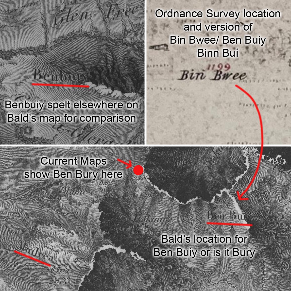
Ben Bury & William Bald
A Scottish surveyor called William Bald surveyed an important map of Co.Mayo in the years 1809-16. It’s a very impressive and completely original work, surveyed accurately using trigonometry at a time when transport was difficult to say the least across the region. The map contains many placenames recorded for the first time and many of these were transferred to the Ordnance Survey Six Inch maps that followed soon after. Not all names carried across though as the survey weren’t much interested in mountain lands.
Mweelrea or Muilrea as older maps have it, will be familiar to many readers here. Who will also be familiar with the name Ben Bury for an adjacent height. This name Ben Bury does not appear on the 1st edition of the OS maps but is added later in the early 20th century. The source for Ben Bury is given as William Bald’s map, shown here. Now have a look at the original – the first thing that should strike you is that the name is not where Ben Bury is currently understood for but rather for the height now labelled Ben Lugmore. Secondly, the text is not very clear and could more likely read Ben Buiy. Given that ‘Bury’ itself is an odd term and that Bald also labels another hill elsewhere with spelling Benbuiy, I think the ‘r’ in Bury is in fact an ‘i’. This is backed up by the OS field records where the name Bin Bwee is labelled in this area. This is rendered Benboy on the published maps.
So the conclusion from examining the map record, is that ‘Ben Bury’ is shown in the wrong place on the current maps. The location is further east and is in fact Binn Buí – the yellowish peak. The name Oughty Craggy is also associated with ‘Ben Bury’ but it’s not clear if this is the same place as Binn Buí or perhaps Oughty Craggy is the height currently labelled Ben Bury. Oughty Craggy could roughly translate as the ‘rocky chest or bosom’.
#eastwestmapping #hillwalkingireland #outdoorsireland #mweelrea