Where is Whelp Rock?
Whelp Rock is one of those places that lingers in the 1798 lore of Co.Wicklow. This is due to the memoir written by the ’98 leader, General Joseph Holt (1756-1826). His book ‘Holt’s Memoirs’ was written some twenty years after the rising and published twenty years later again in 1838. He gives an account of what he recalls of the main events and persons involved and in the course of these stories, a good many places are mentioned including repeated use by rebels of a camp at Whelp Rock.
To follow places mentioned below, have a copy of Wicklow Mountains West, 2nd edition to hand.
For example, Holt writes that he ‘wandered down to Whelp Rock, where I found a great number .. assembled’ and ‘remained unobserved at Whelp Rock’ also ‘The Whelp Rock is situated between Ballylow and Lavarna, in the centre of this dreary and inhospitable district and was fixed upon by me as almost unapproachable to the military’, Whelp Rock is described as a ‘village’ later.
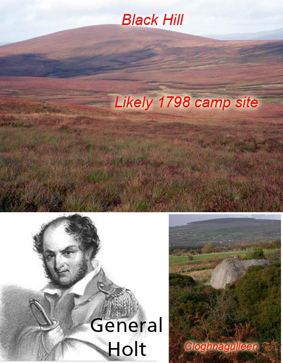
Now Whelp Rock is an unusual name and you’ll find it marked on the OS Six Inch maps of the 1830s on the north western slope of Black Hill overlooking Kylebeg. On making modern enquiries, I found that the name is recognised but the location is vague – the best placing that I could get locally was the rocky slope that continues south from above running towards Kylemore.
However this is most unlikely to be the site that Holt recalls, as these slopes are in wide open view of both Blessington and Baltyboys where squads of yeomen were stationed. Note of course, there was no reservoir in 1798, just the broad valley of the Liffey which could easily be crossed.
There seems to be three possible locations for the 1798 camp called Whelp Rock (1) as given by Martin Murphy of Oldcourt to Liam Price in 1933 and seems to indicate that it in the upper back part of Kylebeg Glen – this would be close enough to the OS location but still barely hidden from view (2) as given by Charles Thompson around 1915 who writes that it’s on the south slope of Black Hill. This is corroborated by elderly John Lennon of Kylebeg in 1938 who seems to indicate that it lay beyond Glanmore, which is the big glen of the Ballynastockan Brook. The Shiney Flags glen/ Shileshawn lies just above this and the 1798 caves are found here but the ground up here by the caves could not have accommodated a great number – it’s too rough. However the broad glen below could and the bend in same would have hidden it from view (3) Holt’s description that it lies between Ballylow and Lavarna and is a village. This is most likely the settlement of Ballinountagh (Ballynultagh on OS). This was and is a hidden valley, well in the middle of the hills with good stations for lookout sentries on the surrounding tops etc. It’s quite possible that there was more than one camp in the area and Holt called them all Whelp Rock. Equally that he had forgotten the exact details in the passage of years.
I’m going to leave you though with where there is a Whelp Rock. It’s a large boulder on the north side of the Ballynastockan aka Cock aka Faw Brook, and the site is marked as Cloghnagulleen on our map. This is variously recorded as Cloch na gulyeen or Cloghernagollion etc. Cloch is of course ‘a rock’ and a dictionary of old Irish gives ‘cuilén’ as a pup or whelp. The modern Irish form is ‘coileán’ – combining the two words would give Cloch na gCuilén which is very close to the anglicised version above. Perhaps foxes or wolves had a den here in the past and the young were often observed here. This rock is also known as a mass rock although you wouldn’t have gathered much of a crowd there. More likely, Cloch na gCuilén was a landmark that you passed as you followed the brook upwards to reach the more secluded glen which is mentioned in (2) above and this upper glen was both the mass site and location of a ’98 camp.