Comeragh Placenames Part 4
Above the steep ground of the popular Mahon Falls lies a broad gently sloping valley. The north eastern slopes of this are known as the Leaca Bhuidhe or Lackawee to local hillfarmers, meaning the ‘yellowish slopes’, where some grazing may be found. These lead up onto a broad tableland, a plateau between all the coums, a place to take care when navigating in the mist. This is one of the areas known as Móin a’ Mhullaigh – the bog on the height or just the Black Bog by hillwalkers.
Canon Power lists Móin a’ Mhullaigh for Kilclooney and this is corroborated by Séamus Ó Maoldomhnaigh of Glenanore in the 1930s Schools Collection, where he describes that on the top of the Comeragh Mountains between Beárna Bhéil an Bhealaigh (The Gap) and Bearna an Mhadra is a flat tract of réidh called Móin a’ Mhullaigh. The name is still known locally for this broad boggy area.
Local people do not now seem to have names for the various high points around this plateau, other than Knockaunapeebra or Cnocán na Phiobaire – the little hill of the piper. Some accounts give that an old travelling piper was found dead at the foot of the hill by a herd from Comeragh village, others say that the piper was from Killrossanty side and died travelling to court a woman from the Nire on the far side. The practical reason that this hill has a name is because of its prominence on the skyline, you’ll easily pick it out from the main Waterford – Cork road.
In the absence of local names for the other principle high points, I have used two names that were in use by the Ordnance Survey sappers in 1841. These were survey stations, trigonometric points and one Moonavoola Hill was used for the height over the Comalochs, whilst Kilclooney Mountain was used for the highest point of all in the Comeragh range, a flattish height just west of Comshinaun. Moonavoola is clearly an anglicisation of Móin a’ Mhullaigh. The name Fauscoum has appeared on maps for Kilclooney Mountain but Fauscoum or Fás Chom is most definitely the name of the coum below this height and south of Comshinaun.
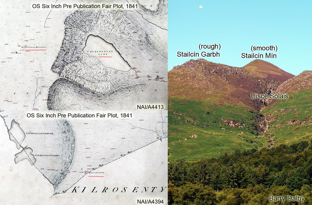
I have written another post about Comshinaun / Coumshingaun and you can see from the attached map extracts which are pre publication fair copies of the OS Six Inch maps, the names above plus the spelling used by the surveyors of the day. I think the change from Coumshenane (Shinaun) to publication spelling of Coumshingaun was likely at the behest of John O’Donovan but in doing so, he clearly ignored common use which still persists to this day.
Making a circuit of Comshinaun is a popular hillwalk and most people ascend by the southern spur whose high flat part is called Drim a’ Chapaill – the horses back. Descent is then made by the northern spur, commonly labelled Stookeenmeen and Stookeengarve. I’ve used the alternative local forms which are recorded in the Schools Collection and still known locally: Stailcín Mín and Stailcín Garbh. Stailc appears to be a local form of ‘staic’, a stake, post or projecting lump. The meaning of above is clearly seen from the main road below as in the attached photo: Stailcín Garbh is the rough, rocky stack, whilst Stailcín Mín is the higher and smoother, boggy stack.
Uisce Solais, Iskesullas etc is the name for the deeply cut stream just north of Stailcín Mín and Stailcín Garbh, meaning the bright water and a reference to how the flowing water glints in the sunlight as it passes over rocks. Lastly Sruthán na nGabhar, the little stream of the goats is the well known local name for the stream issuing from Loch Comshinaun.