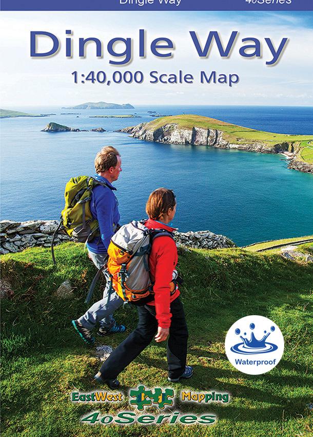
New Dingle Way Map
We published three new maps at 1:25,000 scale for the Dingle peninsula earlier this year and thanks to all who have purchased these and supported the work. In connection with this, I wrote a while back of experimentation with a 1:40,000 map and that whilst feasible, I couldn’t see an application. Well that application became apparent when there were several requests by walking tour operators to have a full detailed map of the popular Dingle Way walking route. Our overseas visitors still like their physical print maps, both to find the way and also as mementoes of their visit.
So in this context I set about distilling & filtering all the 1:25K detail and have prepared a double sided map sheet at 1:40,000 scale with a good 10 metre contour interval. The Dingle Way walking route is marked clearly as also are other signposted walks and greenways. However this will also serve as a general purpose 1:40K map of the region including the Blasket Islands. This scale has become popular across the water on maps published by Harvey Maps with the BMC and Silva Type4 compasses now often have a 1:40K romer scale on them. I’ve made a good selection of detail for this 1:40K mapping but it does not contain the finer contouring or many of the minor placenames and field boundaries of the 1:25K.
Covering 1740 square kilometres, it fits on B1 paper similar to our Wild Nephin map. Whereas recent publications have offered a choice of paper and laminated options, this map is printed on Polyart 90gsm paper. This is a fully waterproof paper and very strong. This map is available in standard folded version and supplied with a wee plastic pocket to keep it tidy. There is limited availability of flat unfolded sheets for wall display etc.
You can view further details and purchase here: Buy Dingle Way Map
We’ll appreciate feedback in due course from customers who use both our waterproof laminated maps and also this new (for us) map on Polyart waterproof paper. To give direction as to what we might use on new maps/ reprints etc. Thanks.
#eastwestmapping #thedingleway #reeksdistrict #irishmaps #cartography