


Set of Connacht Maps
€65.00
Connemara Mountains 1:25,000, Wild Nephin 1:25,000, Mweelrea & The Reek 1:25,000, Achill & Corraun, Clare Island 1:25,000, 1:7500
Description
Connemara Mountains 1:25,000 Laminated
Wild Nephin 1:25,000 Water Resistant
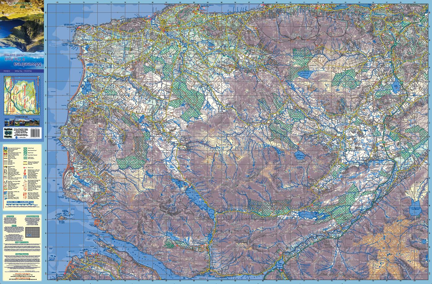
Mweelrea & The Reek 1:25,000 Laminated
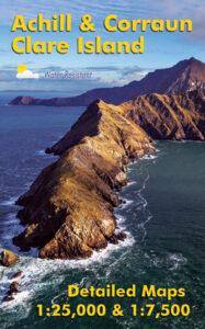
Achill & Corraun, Clare Island 1:25,000 Water Resistant
Connemara Mountains: Definitive detailed map at 1:25,000 scale covering the Twelve Bens, Maumturk Mountains, Killary Harbour and region. Produced to our 25Series standard, this general topographic map has a 5 metre contour interval for fine navigation. Signposted walking trails are depicted. The finest and most detailed of several maps published of this popular region. Printed on good quality Progeo 90gsm map paper, fully laminated to make it waterproof & durable. Published 2020-2024.
Wild Nephin: Detailed map of the Nephin Beg mountain region. Covers Ballycroy National Park, Wild Nephin Wilderness Area, Bangor Trail and parts of the Great Western Greenway and Western Way. Depicts the terrain in very considerable detail for the benefit of anyone exploring this remote region. We have conducted considerable research into local placenames and many names are located & recorded here for the first time. Printed on good quality Enduro 100 gsm paper. Water resistant and tear resistant, read care instructions in FAQ. 1:25,000 Scale, Contour Interval : 10 metres. Published 2015.
Mweelrea & The Reek: Definitive detailed map at 1:25,000 scale covering Mweelrea, the Sheaffrey Hills and The Reek / Croagh Patrick. Produced to our 25Series standard, this general topographic map has a 5 metre contour interval for fine navigation. Signposted walking trails are depicted. The finest and most detailed of several maps published of this popular region. Printed on good quality Progeo 90gsm map paper, fully laminated to make it waterproof & durable. Published 2024.
Achill & Corraun, Clare Island: Detailed map of Achill & Corraun at 1:25,000 scale combined with a very detailed map of Clare Island at 1:7,500 scale. Covers Achill Island and the Corraun peninsula, overlapping with our Wild Nephin map at Mulranny. Depicts this popular region in very considerable detail for the benefit of both visitor and local alike. We have conducted considerable research into local placenames and many names are recorded on a map here for the first time. Printed on good quality Enduro 100 gsm paper. Water resistant and tear resistant, read care instructions in FAQ. Published 2016.
Set of four maps for outdoor use. To view sample detail and map coverage, click on the images above.
Related products
-
-
Set of Three 1:25,000 South Wicklow Maps
- €39.00 – €63.50
- View products
-