Where is Whelp Rock?
Where is Whelp Rock? Whelp Rock is one of those places that lingers in the 1798 lore of Co.Wicklow. This is due to the memoir written by the '98 leader,…
Continue Reading
Where is Whelp Rock?

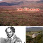
Where is Whelp Rock? Whelp Rock is one of those places that lingers in the 1798 lore of Co.Wicklow. This is due to the memoir written by the '98 leader,…
Silsean ~ Shileshawn We're always happy to hear from people who have information on local placenames and/or who spot errors on our maps. The one topic that I receive most…

Art O'Neill Many people will recognise Art's Cross pictured on the cover of our map, Wicklow Mountains West. The cross itself was erected in 1932 to commemorate the escape of…
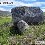
Thanks to map user Paul O’Callaghan for sending on this photo of the Cow & Calf Rock located in Upper Glenasmole in the Dublin Mountains. This large granite boulder is…
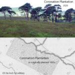
The scattered Scots Pine and Oak trees of Coronation Plantation near Sally Gap in Wicklow are the subject of many a photograph. Planted in 1831 by the Downshire Estate, the…
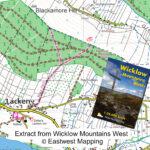
Lacken Mass Path update Customers and users of our Wicklow Mountains West map might like to take note of a useful update at Lacken, Co.Wicklow. The local community in the…
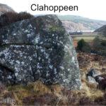
Clahoppeen This is the Clahoppeen rock, it features a few times in the notes left by Liam Price and must have been a notable landmark for local hill farmers in…

Con Costello 1929-2006 Placenames on EastWest Mapping maps come from multiple sources. The best information is collected directly from those who are ‘seed & breed’ of the district, who’ve grown…