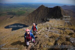
Cailleach of the Hags Glen
Anyone who has climbed Carrauntoohil will be familiar with Com Chaillí, Coomcallee or the Hags Glen. And the two sets of Hags Teeth, Fiacla Chaillí. There are various stories about…

Anyone who has climbed Carrauntoohil will be familiar with Com Chaillí, Coomcallee or the Hags Glen. And the two sets of Hags Teeth, Fiacla Chaillí. There are various stories about…
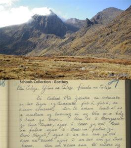
The 1930s Schools Collection of folklore contains some interesting information on the Reeks and Killarney area. In particular, the records for Gortboy school on the way up to what people…
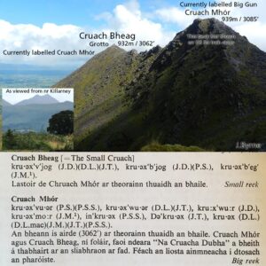
Reeks Placenames Query 5: Cruach Mhór & Cruach Bheag The name Cruach Mhór (big stack/peak) first appeared on maps abt 1978, located on the peak 932m where you’ll find the…
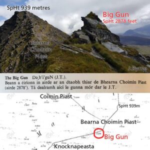
Highlighting another wee query relating to Breandán Ó Cíobháin’s placename research for the Reeks area, undertaken about fifty years ago. The Big Gun is a name that has appeared on…
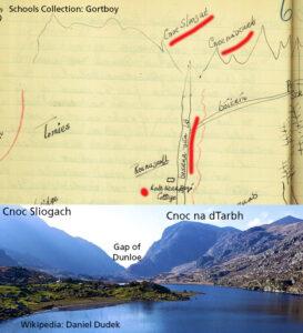
Reeks Placenames Query 3 Highlighting another wee query relating to Breandán Ó Cíobháin’s placename research for the Reeks area, undertaken about fifty years ago. The highest point on the Eastern…
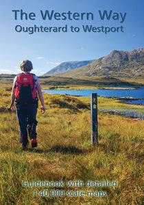
To advise that we have a new edition of our popular Western Way map guide which details the route of this 100 kilometre scenic walk from Oughterard in Galway to…
If you ran the IMRA (Irish Mountain Running Association) Wicklow Way Half Marathon last Sunday, you should have received one of these unique buffs/ snoods as a reward for your…
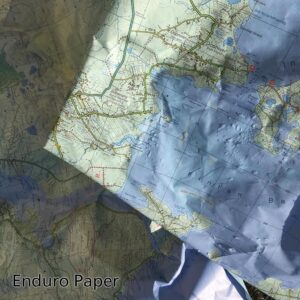
Photo here is of some ‘scrap’ Achill & Corraun maps which are printed on Enduro paper. We used them as floor protection when painting walls recently and they were then…
Highlighting another wee query relating to Breandán Ó Cíobháin’s placename research for the Reeks area, undertaken about fifty years ago. Turn left or east at the Top of the Ladder…
As per previous post, I’ve been reading carefully though Breandán Ó Cíobháin’s placename research for the Reeks area, undertaken about fifty years ago. A number of the names he lists…